Saturday, July 18, 2015

Where is El Nino when you need him?

In Australia, El Nino manifests as a period of below average rain.  On one recentish event of this nature we were up Cape Yorke, where it rained most days and I was given, by a friend of Uruguayan birth, the name La Vieja Regonzonda (the Old Hag) gave a picture of the opposite.

On Thursday evening (16 July) we had decided that the weather forecast for strong winds at Corindi meant we should redirect ourselves to Grafton before going on to Kingscliff.  On Friday morning (17 July) we checked a little more and discovered that while the coastal winds would have died down a bit by Sunday 5-20mm of rain were forecast on Meteye for Kingscliff on that day and around 5mm per day for the following 3 days.  To illustrate this, here is the forecast from BoM as shown at 7:20 on 19 July:

The Thursday and Friday are similar, as is the forecast for Kingscliff currently shown on Meteye.

We couldn't find anywhere better in the direction we were heading so decided that, as we were about as far as we wished to get from Carwoola for a single days drive home, we'd pull the pin and head for home.

At that time the weather was quite pleasant in Port Macquarie (albeit a little cool).  However before we got to Taree (75km South) the wind had risen to be whipping the trees around and occasional gusts could be felt on the steering.  The temperature had dropped to 8C.  A good decision appeared to have been made.

Getting close to the Hunter Valley the scenery began to disappear.
As we passed a sign pointing to Nelson Bay serious rain started to happen.   Before we got as far as Raymond Terrace a large information sign informed us that

  • the New England Highway was closed between Amidale and Inverell; and 
  • the Oxley Highway was closed around Walcha.

The cause wasn't mentioned but I thought snow more likely than a bushfire.

The rain had stopped before we got to the Hawkesbury (so it was again the curse of Pt Stephens in evidence) and by the time we got to Pennant Hills the temperature had risen to 15C.  To dispel complacency, after filling up with diesel and embarking on the M2/M7 we came across further information that:
  1. the Great Western Highway was closed; and 
  2. Bells Line of Road was closed.
We thought about the confusion that would cause and pressed on to the Hume Highway on which the traffic was pretty heavy.  At least one vehicle which passed us was advertising Cowra , so I guessed that some of those who wanted to go on the Great western were heading for Goulburn and going North.

Just before (ie East of) Mittagong I noticed that the hills were rather white.  We didn't get a snap of that, which didn't matter as we - or at least Frances - scored plenty of photo ops to the West of the town.

Note the cars parked on the shoulder taking photographs.  A few hundred metres back there had been about a dozen pulled over.  Possibly they didn't realise that the memorial marker where they were standing was to a poor woman and a tow-truck driver who had been killed parked at that point while standing beside the road..
Note also the line of snow in the central reservation: clearly someone had ploughed the road.  In the Saturday Canberra Times I read that the road had been closed at Berrima for several hours in the morning.

So at 16:44 (4:44pm for the old fashioned folks who live, for example, between Mexico and Canada) we rolled into home, lit the fire and enjoyed comfort.


Vada Heads of the Mid-North Coast

Bird of the day: Eastern Reef Egret.  
The big flock goes to an enormous collection (about 150 birds) of Hardhead in the Belmore River..
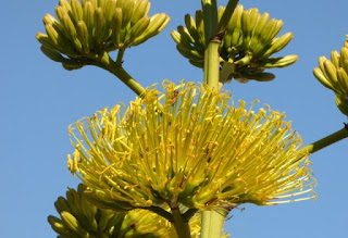
Flower of the dayAn unknown aloe in a garden near Flynns Beach
Garden of the day: No award today..
Geological feature of the day: Two colours in adjacent  rocks at Nobbys Beach.
Other contenders will appear below, only slightly unhappy at missing out on the biggie!
Outstanding Weather feature of the day; Warm and sunny all day!  Not the forecast for this area tomorrow!
Council behaviour of the day: Bouquets for dog access at Lighthouse Beach (Port Macq) and Hat Head (where the Council appeared to have controlled NSW NPS).  A brickbat for the restruicted hours at Crescent Head.

As we set off for our dog walk a blimp was cruising over the town.  It continued to do this all dy, showing that the wind was very light.
This is a view of the headland at the South end of Nobby's Beach.  The purple arrow marks the obelisk on top of the rock.
In the evening - you should excuse the jump in time - I climbed up to it on a rather steep track which would be great fun if wet.  The obelisk commemorates two guys who died at the base of the headland in 1874 - one who got into trouble in the water and the other who jumped in to try to save him.
Getting back to the dog walk, this is the whole plant of 'flower of the day'.
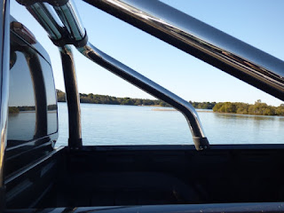
Our main expedition on this day was focused pn Crescent Heads about 30km North.  To get there we took a ferry across the Hastings River.  I took a snap of some pelicans on a sandbar but decided that the roll cage on the ute next to me made a nicer image.
We took the Maria River Rd to Crescent Head expecting this to be good for birding.  In fact it was just about devoid of birds and there was no sign of the River.  Most vegetation was in a Nature Reserve which apart form being canophobic had no obvious means of public access.

As well as the reef Heron which was Bird of the day our first Darter of the trip was on the rocks at Crescent Head.
In the water were many surfers.  Apparently the town is famous for its break, and is also a convenient distance North of Sydney for those heading up the Coast to stop off.
The strata on the headland to the South of the town were a  contender for geological feature of the day.
There were two traditional signs on most beaches: one banning things (eg dogs) and the other setting out bag limits.  It would be interesting tosee if these vary by site or follow some standard.
The Crescent Head War Memorial.
Frances had a conversation with the lady in the bakery (who gave good pie, and excellent pumpkin bread) and she suggested going to Gladstone and some other small towns up there.  Gladstone had an interesting War Memorial is that it was a street (Memorial St) with 10 small posts topped with memorials to individuals who had died in conflicts from the Boer War to WW2.
The town also had this rather spiffy, and large Police Station.
Overall it seemed a rather pleasant and well-looked after town.  This became particularly interesting on the way home when we crossed the Macleay River to Smithtown, the site of a huge Nestlé factory.  The latter town was run down and daggy - obviously where the workers lived.  It didn't have a Memorial of any sort so isn't really a town!

In between visiting those two settlements we went to Hat Head.  This about three streets lined with holiday shacks, plus a canophobic caravan park,  To our astonishment the beach was an off leash area so on we went.  The beach was magnificent - and not crowded.
We headed back home through Kempsey finding a memorial to the dead of the Macleay District as we went.
By now we were getting a little low on fuel so swung into a service station which was charging 142c/l which was a fair bit better than the 145c/l being asked in Port Macquarie.  Then I found that they were adding 1.5% to the bill if you used a credit card so moved on.  In fact we moved about 400m down the road to a place which charged 134c/l! Go figure the economic rationale of that.  (The next day, as we left Port McQ a place on the highway - about 10km from the town centre- was asking 132c/l which is even more bizarre.)

We had some daylight left when we got back to Port Macquarie so I climbed up to the obelisk as reported above.  On descending a Brahminy Kite was perched on a rock.  I really like these birds, which seemed to be very common on this trip.
We then moved down to Lighthouse Beach, which Frances had visited the previous evening.  It took a bit of reading to work out where the dog area was but it started at these arher magnificent rocks.
Another magnificent beach - the specks in the distance are some of the many folk exercising their pooches.
The dog friendly area was quite well used which the canophobic area was unoccupied (apart from one person transiting it with their dog, and a surfer leaving the water).  That demonstrated the total daftness of year-round dog restrictions.

The cloudscapes were very attractive.

Back at the camper we reviewed the weather forecast for the next few days and decided Corindi, with 50kph wind, was not what we wanted so decided to head for Grafton instead.

return to index page.

Thursday, July 16, 2015

Memorials all over and Old Bottlebutt

Bird of the day:  Gull-billed terns at North Haven
(narrowly over Bar-shouldered Dove at Old Bottlebutt ).  The first-named locale also delivered flock of the day with a dozen Australasian Pelicans.
Flower of the day:Very few contenders.  Camellias win as they are both evident and unexpected here.
Garden of the day: A well structured planting in front of a mural at Wauchope.
Geological feature of the day:  sedimentary layers in a rock at Nobby's Beach
Outstanding Weather feature of the day; Delightfully absent: as hoped for (and expected) sunny, still and warm.
Council behaviour of the day: Stretching the definition of 'Council' to include State Forests, their effort in setting up the Old Bottlebutt facility in Burrawan State Forest was an excellent example of encouraging good use of a forest.  Yest they are trying to counter änti-logging, but they are doing it well.

On to the details of the day.  We had a good night's sleep and din't emerge from the cot until after 7am.  It was still only 5<sup>>o</sup>C so it took some time to drink the coffee and head off for a walk.  This was to Nobby's Beach, an off leash area.  Dog's were off leash everywhere.
 The first incident was when Tammy (still on leash)  was charged by a small poodle that leapt over her.  Then we encountered a 15 week old Border Collie that wanted to play.  Tammy displayed great speed in outrunning the pup and also a lot of agility in dodging it.  Then she got fed up and just headed off, leading me to sprint after her with a lot of yelling.

WE then extended the walk along the Kenny Walk to the next beach South.  En route we passed a couple of rock fishermen who seemed unfamiliar  with the term "risk assessment " but seemed likely to learn about the word "drowning" if a big swell came in.
We returned from whence we had come passing this boulder of serpentenite  ..
.. on our way to Flynns Beach crossing over a headland.  On arrival we were greeted with a canophobia sign which we ignored (as we didn't want to backtrack several hundred metres) and thus back to the camp.

Our expedition for the day was directed South and then West.  Still within the urban area we looked down on Lighthouse Beach, which Frances visited in the evening, and reported was as nice as it looks.
After a couple of stops to check birds we arrived at Laurieton, named after the original developed.  The War Memorials there were set in a park and covered a lot of the area.  This, featuring a woman with a wreath rather than a digger, was the main one.
Several of the trees were decorated with crosses.  These three were honouring three men who died in Afghanistan.  I can find no connection between them and Laurieton, but that is not a problem for the honours.  (The woven poppies are the second lot I have seen, the first were in Broken Hill.)
This commemorates a member of the Laurie family who died at Messines in WW1.
A smaller memorial at Kew.  Evidence of the forestry-town nature of the place is the axe mounted behind it.
The small town of Kendall is next to Kew (and judging by the real estate activity between them they will soon merge).  The town is named after Henry Kendall whose plaque refers to him in large font as a poet.  Smaller font shows he was the first Forest Inspector for NSW (and the memorial was assisted - presumably financially -  by State Forests).
The Kendall Memorial was now the CWA Hall, and only open once a month.  Who knows what is inside?
After leaving Kendall we headed towards Wauchope, up the Bago road.  This ran beside the Burrawan State Forest which was pet friendly and advertised "Old Bottlebutt".  This looked interesting so we headed off and found ourselves at a 600m walking trail.  We did the loop anti-clockwise and encountered a forest of what I take to be Livingsonia australis palms.
Then we got to Old Bottlebutt a huge Corymbiya gummifera.  This is the top.
Here is the bottle-shaped butt, about 16m around.  It seems no one knows what causes these engorged bases, but it is 'natural'.
On getting to Wauchope - a timber town.  We soon found the War Memorial.
I rather liked this Koalart - part of the Koala Art trail around the area.
As we got into Port Macquaruie, and having some time on hand we - or rather I - swung into the Little Brewing Company, rated highly in a book I read.  This is the entrance to the premises, with their awards on the wall.

I passed on the tasting as I wanted to go for a run (but was impressed that the charges they levied went to cover the tax they had to pay on them and then to the Koala Hospital.)  They had a Koala Art in Panda colours outside!  8 bottles were purchased - consumption reports to follow, possibly on return home as they start at 5.2 ABV and go up.

On return to the campsite we found Natures go at Koala Art in a tree almost above our site.

It was very active: this was the first time I have ever seen a Koala jump from one branch to another

return to index page.

Wednesday, July 15, 2015

Bona tempus -finally

I can't find a Polari word for weather so have invented one, based on French.

Lets run through the awards for the day.
Bird of the day:  Pied Butcherbird.  Flock of the day was about 50 Straw-necked Ibis. 
Flower of the day:Very few contenders.  The winner was this yellow jobbie outside the door into St John's Church in Raymond Terrace.
Garden of the day: Well won by some trimmed privet and Camellia in a park in Taree.


Geological feature of the day: This was a view of the escarpment from 4 Mile Hill outside Taree.  Sorry, no snap.
Outstanding Weather feature of the day; Warmth and stillness at Port Macquarie.
Council behaviour of the day: Whoever the idiots were who closed off a lane on at least a kilometre of the Pacific Highway for weed mowing.  And were then sitting there having their lunch as we drove past at 40kph!

The weather at Fingal Bay was not good and we were concerned it had damaged the camper.  If this was the case we were going to abandon and return home.  However we persevered and by the time we got to about Taree things were pretty good.  As we sat outside tonight to eat tea they are also good at Port Macquarie.

Finally we can answer "Yes"to "Are we having fun yet?"

After a very ordinary half nights sleep- the wind had dropped but the camper seemed to be groaning more we decided to head to Port Maquarie and see what happened.  (The alternative was to throw in the towel and go home.)  Our first stop was Raymond Terrace where the Town Clock deluded us into thinking we had a Memorial.
This was the Memorial, a block off the main drag
In writing about Soldier's Point I commented on the roof over the bowling green.  A similar structure was at Raymond Terrace and on enquiring I was told it was to keep both rain and sun off the bowlers
Another Memorial built into a wall at St Johns Church.
On to Buladelah for another Memorial and lunch.
Quite a few kms further up the highway was Taree.  They had an excellent Park around the Memorial with a clock-obelisk for WW1 and polished marble for WW2.
A bit further into the park were some interesting sculptures.  I particularly liked the top portrait on the LH pole!
This overall work was pretty good ...
....  but where the rainbow serpent meets M S Escherwas particularly clever
They had even printed nice images on their litter bins!  The small child is asking if she can pat Tammy (who was exploring the back of the bins - perhaps something had been spilled)!
Two more sculptures in the main street (note the goanna on the ground).
Cundletown is on the edge of Taree.  Despite being on the main drag - inspirationally named "Main St" - this Hall was not in the Register of NSW Memorials: it is now!
After some limited help at the Port Macquarie VIC we found our way to the Flynns Beach caravan park and checked in.  It was warm enough to sit outside untill after dark!   The lady manager said they had koalas but all we found today was this Brush-tailed Possum in the tree above our site.