Showing posts with label Eyre Peninsula. Show all posts

Monday, May 28, 2018

Bird list for SA trip

Emu
Cape Barren Goose
Freckled Duck (Big Swamp, Port Lincoln)
Black Swan
Australian Shelduck
Australian Wood Duck
Australasian Shoveler (Big Swamp, Port Lincoln)
Pacific Black Duck
Grey Teal
Chestnut Teal
Pink-eared Duck
Australasian Grebe
Hoary-headed Grebe
Australasian Gannet (Whalers Way)
Little Pied Cormorant
Great Cormorant
Little Black Cormorant
Pied Cormorant
Black-faced Cormorant
Australasian Darter
Australian Pelican
Great Egret (Glenelg and Thompson's Beach)
White-faced Heron
Little Egret (Thompsons Beach)
Australian White Ibis
Straw-necked Ibis (McLaren Vale)
Royal Spoonbill (St Kilda)
Yellow-billed Spoonbill (Port Noarlunga)
Brown Goshawk
Black Kite
Black-shouldered Kite (Australian)
Swamp Harrier (St Kilda)
Wedge-tailed Eagle
Whistling Kite
White-bellied Sea-Eagle
Australian Spotted Crake (6, St Kilda)
Australasian Swamphen
Dusky Moorhen
Black-tailed Nativehen
Eurasian Coot
Pied Stilt
Banded Stilt (100s St Kilda)
Red-necked Avocet
Australian Pied Oystercatcher
Sooty Oystercatcher
Masked Lapwing
Red-capped Plover
Red-kneed Dotterel
Curlew Sandpiper (St Kilda)
Red-necked Stint
Silver Gull
Pacific Gull
Fairy Tern (Little Douglas)
Caspian Tern
Crested Tern
Rock Dove
Spotted Dove
Brush Bronzewing
Crested Pigeon
Sacred Kingfisher (Coffin Bay)
Southern Boobook (Torrens Linear Park)
Nankeen Kestrel
Brown Falcon
Galah
Sulphur-crested Cockatoo
Long-billed Corella  (Torrens Linear Park)
Rock Parrot (Dutton Bay)
Australian Ringneck
Red-rumped Parrot
Crimson Rosella (Adelaide  Rosella)
Eastern Rosella
Musk Lorikeet  (Torrens Linear Park)
Rainbow Lorikeet
Superb Fairywren
White-winged Fairywren (Whyalla Wetland)
fairywren sp.
Noisy Miner
Spiny-cheeked Honeyeater (Salt lakes North of Coles Point)
Red Wattlebird
Singing Honeyeater
White-plumed Honeyeater
New Holland Honeyeater
Shy Heathwren (Dutton Bay)
Brown Thornbill
Inland Thornbill (Dutton Bay
Dusky Woodswallow
Grey Butcherbird
Australian Magpie
Grey Currawong
Black-faced Cuckooshrike
Grey Shrikethrush
Willie Wagtail
Grey Fantail
Magpie-lark
Australian Raven
Little Raven
White-winged Chough
Eurasian Skylark
Welcome Swallow
Silvereye
Common Blackbird
Common Starling
House Sparrow

An alert reader will notice that there is no mention of Common Myna in the list.  I have raised this on the birding-aus email group and have been advised, by various members of the group, of the following:

  • "The South Australian authorities  are trying very hard to keep them out. Unfortunately the Victorian authorities are not particularly interested in dealing with birds that turn up in western Victoria."
  • "I collected specimens for the museum in the mid 1950s and when I left in 1958 they were a number of sightings so the might have died out."
  • "There was one in Adelaide airport a few years ago - I think it was eliminated."

Monday, May 21, 2018

Transfer to Glenelg

Today was the day we shifted from Dutton Bay to what South Australians - at least those who live in Adelaide -  refer to as The Bay: Glenelg.

Following from comments earlier about how  the Port Lincoln area appears to have 'branded' (cough, cough vomit at that word) itself as the Seafood Coast we mused as to how Adelaide would brand its coastline.  Frances came up with Culture Coast, which is probably a good idea of something the glitterati of Adelaide would sign up for.  I preferred the Crow-eater Coast, although that  reference to South Australians has probably joined bonza and strewth as a non-word.

As I had discovered the previous day that it was only 700km between the two residences we had a fairly relaxed packing of the car and it was close to daylight as we drove away from Vandy's Shack at 7:15.No kangaroos were harmed during the drive to Port Lincoln where we hung a left and headed for Port Augusta.  I was able to spot these cultural artefacts on the edge of the town as we headed North.
Traffic was very light: on several occasions I noticed about 20kms between crossing with another car, and I don't recall overtaking car until close to Whyalla.  The country looked very dry and barren as we went up the road.  Just about every vestige of bush has been cleared and the sown crops haven't yet germinated despite fair recent rains.
This colourful  hillside didn't show up as well as I'd hoped, possibly due to the murky cloud.  The weather forecast was "mainly cloudy": for the first 3 hours it was about 99% cloudy!

I had hoped to spot a sculpture of an emu made from rusty barbed wire but alas I didn't notice  it on this leg.  So we navigated Port Augusta and turned South, running past the Lower Flinders Ranges.

 The road was a little busier than the stretch up from Port Lincoln.  We heard a story on ABC News about how truckies were fed up with caravans driving slowly and blocking up the areas where trucks can park for the required sleep breaks.

Then we came up behind a B-double doing less than 70kph.  Sure enough, in front of it was a large campervan (like a small Winnebago, although not that make) an in between them a sedan that wouldn't overtake even though a few chances appeared.  After about 4km of this we passed a sign saying "Overtaking lane 5km" and settled down for another ~5 minutes of annoyance.

As we approached the overtaking lane it looked as though the 'van was going to speed up, but it then dropped back to about 80kph.  As soon as it could the truck pulled out and passed the vermin, dropping back in quickly so we could also get by both of them. Frances looked at the van driver: oldish male, leaning across yakking to his passenger: no idea at all that there were a dozen other vehicles queued up behind him (some of whom probably had to wait another 10km to get past).

Whatever.  We rolled on down the road and hooked in to the metropolitan area, taking the North-South Expressway.  This was an elevated expressway for a few kilometres and then dropped down to the usual narrow, crowded South Road with a subterranean expressway-under-construction next to it.
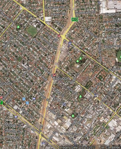
That clip from Google Earth shows the stretch covering both Port and Torrens Rds where the intersections were effectively closed.  Work on the completed bit (4.8km) began in 2011 and it appears the sunken stretch currently being worked on is to be completed in 2018: the rest of the road, from the Torrens to Darlington appears to be unfunded yet.  So they have got a few minor issues (including massive chaos for years as every East-West road south of the River has to be overpassed; buying a whole lot of land and houses) to deal with.  My guess is this will not be completed before 2040.

Whatever.  We were fascinated in Port Lincoln to see the price of diesel jump 7 cents per litre between Tuesday and Saturday.  The 'new price' 155c/l was evident everywhere until we got to Henley Beach Rd where it suddenly dropped to 146c./l at a BP station and then went even lower at Liberty.  I'm sure that this is all kosher and fuel companies don't collude.

After a minor navigational snafu by me we got to our new accommodation and moved in.  We decided to go for a short walk around the area to stretch our legs.  An early observation, at the Sturt River (now a concrete drain) was that it was totally fenced off by SA Water.  They really do seem to be a very authoritarian organisation, even by the low standards of water companies.

Then down Tapley's Hill Rd which was very busy and noisy.  I noticed this place, which must be awaiting the due process to allow high rise to be developed.
 It must have been vacant for years to get the rainwater tank into that condition!

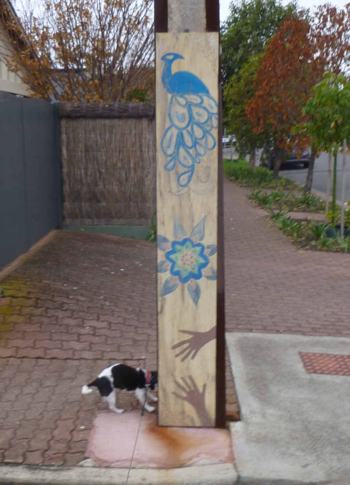
We decided not to go as far as Anzac Highway but swung back into the 'burb.  The noise from the road died away almost completely within a block.  It seemed a very pleasant area with a mixture of old houses (such as the one we're staying in), new houses on a standard block and places were a standard block had been subdivided.  This decorated stobie pole showed that there was a bit of interest in making the area attractive..
Getting back home we had tea and went to bed.

Back to index page

Sunday, May 20, 2018

Last day at Dutton

In my main blog I often put up photos of dawn from Mallacoota.  On the 19th there was a more subdued, but still very good looking sunrise over Dutton Bay.


 On the dog walk I finally got some colourful Samphire in focus.
 A Pacific Gull in an archetypal pose.
In yesterdays's post I included a photo of some plastic owls, intended to keep birds off a pontoon.  It is possible that this image of Dutton Bay Jetty illustrates what they are trying to avoid.
 I suspect this boat is getting a similar treatment.
 A local was engaged in squid catching, and appeared to be quite successful.
 A colourful squid!  (I usually see them coated in batter so don't know what is a typical colour.)
 In yesterday's post I omitted the roof of the woolshed.  Its actually pretty good as rooves go!  It was originally built in 1870 and held up to 100,000 fleeces from the run which went from Dutton Bay to North of Elliston (~140 km by road).
 Dew drops (or raindrops, your call) on the Allocasuarina.
I suggested on Facebook this might mark where the Saints aspirations for 2018 were interred.  My expert adviser on matters to do with Moorabbin reckons the aspirations are much lower than high water mark!
Getting back to the house and Tammy displayed her usual level of fear of one of the local mutts who came for a visit.
 Our main expedition for the day was to visit some parts of Port Lincoln.  We began by a side trip to Blue Fin Rd, which looked down on the bays of Port Lincoln
The catalyst for visiting this area was to investigate - for some folk interested in weather - a hill in Kathai Conservation area.  Unfortunately the obvious access route is controlled by SA Water who have posted notices with harsh words and dire threats on the locked gate.  As the rest of the area seems almost impenetrable scrub we had to be content with this image.
We had been intending to be in this part of Port Lincoln anyway to do a walk to Murrays Point where we had seen some orchids previously and had read good comments about the birds.  It was a very pleasant walk with a slew of White-faced Herons and Oystercatchers and then this nice aggregation of waterbirds at the Point.
 Looking closely at the two shags on a rock and the one on the right, with yellow facial skin and a pale bill, is a Pied Cormorant while the leftie with black face and bill is a Black-faced Cormorant.  Very obliging of them to pose in such an easy-to-compare way.
 After a bit more walking along the Bay we cut back inland along this track.
 Frances then spotted a yellow bird.  A Western Yellow Robin!  Note the grey breast (and also reflect on the nearest Eastern Yellow being about 350km away near the Coorong).  My first lifer for 2018.
On the way home home we briefly explored the Coast of Kedillie Bay, opposite the town of Coffin Bay.  Quite pleasant but we were getting weary on it.  The best bird was this (again obliging) Brown Falcon.
 Each tiom we had driven in and out of Dutton Bay we'd noticed signs to the Pig Farm.  By chance we went past it on this outing.  The pigs looked very happy trotting around their limestone coated paddock.
The late afternoon was spent packing as far as we could, followed by watching the harry-Meghan festivities on the TV.  Yes I know, but it was interesting to see a big production number done very well.

Back to index page

Saturday, May 19, 2018

Coffin' at the cost of Oysters!

We began the day with a walk to the Dutton Bay woolshed.  A resident was gathering the roo poo from his lawn so visitors didn't track it into his house, and he invited us to walk through the revegetation area on the low dune.  This avoided some boggy bits (in one of which Frances lost, but regained,  her shoe last time we did this).
No dead dogs were found on this walk.  This Kelpie spotted Tammy and just laid down in front of her.  After being thoroughly sniffed she got up and followed us around.
This shows (most of - the roof doesn't matter) the Dutton Bay Woolshed which is being restored as part of a tourist attraction.  It doesn't look any different to when we were last here, 6 years ago.  The adjacent campground was getting a bit of action from caravans so I presume the owners of the areaare doing OK.
As we strolled on the jetty the large dog accompanied us.  This stroll gave us good views of a stingray swimming under the jetty.

We went back traversing an area where the seaweed had washed up.    I liked the three colours!
After a bit more to eat we headed to Coffin Bay to do parts of the Oyster Walk along the foreshore.  We did the red bit (probably 3km return) before lunch and the yellow bit (2.5km) after.
It was showering as we went out on the morning walk so I didn't take a photo of the bunch of people sat under this shelter eating oysters.  The deal is to wade out to the platform and capture oysters - presumably getting trained in shucking - and munch.
I presume the plastic owls are there to dissuade gulls and cormorants from crapping on the deck.

The walk is very good.  Near the start point it goes very close to people's houses (I would be interested to see how close the houses were built to the boundary of the block) which could be very strange in Summer when the houses are fully occupied.  A bit further on some nice mosaics of the usual suspects - starfish etc - had been set into the path,
I was rather surprised to see a Sacred Kingfisher still present.  As we saw one on the afternoon walk, about 3km from here so I think they were different, birds they must overwinter rather than heading North,
A flower!  Hakea cycloptera.
This was an attempt to get the Hakea flower and a 'nut' in the same image.  At least the mulch on the ground is in focus!
We had to turn at the edge of town as the bush area there is owned by the Department of the Environment  so dogs are banned.  It is surprising how Council Parks are generally so much more sensible that the ideologically driven State Government gulags.

One of the new McMansions adjacent to the walk.  Very architectural with a galvo kangaroo to the left of the deck.
A view across the bay.
Closer my Pelicans to thee,   I guess they are aso dissuaded from the oyster munching area by the owls!
This is the scene outside the cafe from which we got some excellent crumbed whiting for lunch.
I suspect the waders are those provided for the oyster munchers.  I am not sure how much they charged for the full oyster munching 'experience' (cough, splutter - I do apologise for that use of the word) but they were like unto a wild bull for the shucked items in the shop.   $17.50 per dozen for opened oysters is about $7.50 more than is charged in Canberra .  So they were left in the fridge.

The second stroll passed a good number of Quandong (Santalum acuminatum) bushes with very unripe fruit.  As well as anything else, there were a number of very informative signs along the walk.
A view down the bay towards the sea
A clip of some of the closer dunes.
These monsters are, as measured on Google Earth, 10km away, which I think explains the hazy quality of the image,
At the close of the walk a Singing Honeyeater appeared!
Back to index page

Friday, May 18, 2018

Salt Lakes

I had wondered about including a trip to the next town North (Elliston) in our itinerary.  But it was quite a way and we have enough other driving to do on this trip.  Frances suggested there were a lot of interesting looking Lakes in that area so we could cast an eye into them.  That seemed like a good idea and after checking Google Earth found a couple of potentially interesting coastal sites on the way, so included them as well.

First up was checking the birds on the water followed by a a short walk along the road.

This image is included to show the differences between Pied and Little Pied Cormorants.  It's at fair range on a pretty dull morning but difference and body shape is size is very obvious.
The first flowering Acacia (A. gillii).
On the main outing our first stop was at Frenchman , a rocky area adjacent to Mount Frenchman.  These spots are a reference to the French whalers who used the mountain (at 168m high, really only a hill) as a look out.  Rock Parrots were there, living up to their name.
Here is the view North ...
.. and South.
There are many ruined cottages around this area.  The juxtaposition of a real ruin and another cottage that looks to heading in that direction was intriguing.  (As we drove past another complete ruin appeared on the far side of the better one.)
Coles Point is named after the family that farmed most of the surrounding area.  The rocks held the biggest flock of Crested Terns I've yet seen on the trip.
This is Mount Greenly, a real mountain at 308m AMSL.  It was named by Flinders after the fiancee of Sir Isaac Coffin who helped with Flinders expedition.
The rocks at Coles Point were the first that showed signs of folding.
The Correas (C. pulchella) were very common.
Once we got back to the highway we got to the first Lake which got within 80m of the road.  That is proved by this snap of the car from the shore.
Looking the other way, here is the 'Lake':
It is more of a salt pan.  I didn't test the surface as I have in the past found that if one goes through the crust the mud underneath is:

  • deep;
  • black; and
  • very smelly.

The only birds seen  here were a group of Shelduck vaguely visible through the heat haze.  (Although only 18oC there was obviously a whole lotta convection going on.)

We proceeded North to this area we'd noticed on Google Earth, and dived inland along the route marked in red.
Here is one of the Lakes.
They were not all as dry as this but all equally well devoid of waterbirds.  This intrigues me as to why there were no ducks or waders.  It shouldn't be the salinity of the water as waders are quite happy in the ponds at the salt fields North of Adelaide and indeed the major salt lakes in the deserts of North of Port Augusta.  Perhaps it is something to do with fertiliser run off from the surrounding farmland?

We did see some interesting birds around beside the road including 3 Wedgetailed Eagles, 6+ Dusky Woodswallows and a very vocal flock of 12 Spiny-cheeked Honeyeaters.  Finally on the outskirts of Kappinie we found a small pond with 7 Pied Stilt and two Red-kneed Dotterels,
On getting back to the Highway we went a little further North to Mount Hope.  My particular hope was that is would have a bakery.  Nope.  About 4 houses and a Memorial Hall (or two).
 One of the houses had a new looking car parked outside and my guess was the car was worth about the same as the house!

We took a further side trip to the cemetery.  It was a bit surprising that it was 1.5km away from the hamlet,  We couldn't work out why this was so: perhaps Eyre Peninsula corpses are particularly prone to zombieism?  I'd expected it to have a lot of old graves and very few new ones.  I was therefore surprised to find that most of the headstones were quite new - nearly all from the 1980s onwards.
It was also surprising, in view of the (apparently marginal) nature of the country to speculate on the likely cost of some of the headstones,  The local undertaker is clearly on a nice little earner.

The paddock behind the cemetery showed that despite the apparent lack of rain whatever had been planted was growing well.
It was then simply a matter of toddling down the highway back to the house.  As we got nearer to Mount Dutton I noticed that the vegetation had changed with a lot of quite large eucalypts rather than the very low shrubs of the coastal areas.  Perhaps the country isn't as marginal as I'd thought.

To get a handle on that I looked at the BoM rainfall stats for Mount Hope.  Astonishingly they appear to have a continuous series since 1903!  That shows there are to have a pronounced Mediterranean rainfall pattern with most of the 405mm average falling between May and September.  2018 to the end of April seems to be about on the median and they score over an inch (27mm) on May 3rd and are well on their way to median May rainfall.

Back to index page